Politics
Extremism Desk Publishes A Range Map; The Species Migrates Toward Cameras And Flushes From A Single Photograph
Four years of sightings, plotted. The range is not a place. It is a signal footprint.
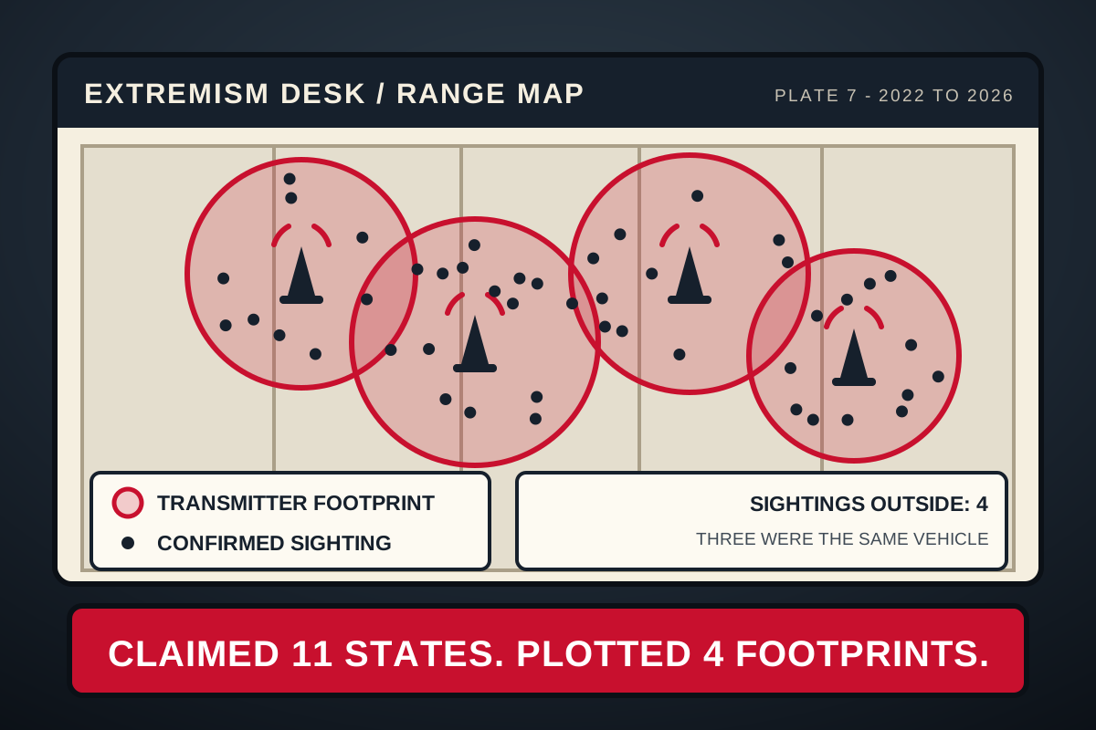
The desk has kept a sightings register since 2022. Every confirmed appearance of the species is entered with a date, a location, a count, and the claimed count, which is entered in the adjacent column and never reconciled. The register now holds 214 entries. Plotted, they make a range map, and the range map is published today because it has stopped changing shape, which in field work is the point at which a map becomes useful.
A range map ordinarily follows something: a watershed, a treeline, an elevation band, a food source. This one follows none of those. The boundary is not geographic. Overlaid on terrain it is nonsense - it crosses three mountain ranges, skips two entire river valleys with excellent access and ample parking, and stops dead at a state line that no animal has ever been able to see. Overlaid on broadcast coverage maps it resolves immediately. The species ranges where it can be recorded at distance. Outside that footprint there are four sightings in four years, and three of them were the same vehicle turning around.
Flush Distance
Flush distance is the range at which an animal breaks and leaves. It is the first thing you measure and the most reliable number in the file, because it does not care what the animal would prefer you write down. For most wary species it is a simple function of proximity: closer is worse.
It is not proximity here. A broadcast camera on a tripod at forty yards does not flush them. It draws them; the formation adjusts its line to present the shield faces to the lens, which took the desk eleven sightings to stop attributing to coincidence. A telephone held at six feet does not flush them either, provided the frame is wide. What flushes them, reliably, at any distance measured so far and out to a hundred and ten yards, is a lens aimed at one of them. The variable is not distance. It is how many are in the frame.
"The behavior is not shyness and I would not print it as shyness. Shy animals avoid the camera. This one arranges itself for the camera and objects only to being counted as one." Field note, entry 187
Corridor
Migration corridors are the part of a range map that takes the longest and reads as the least interesting. This one runs 2.4 miles and it is the ramp of a municipal parking structure. The species enters the corridor dressed as individuals, exits it dressed identically, and reverses the process ninety minutes later on the same level. The structure charges eleven dollars and the desk has a receipt, entered in the register, from a member who paid it and kept the stub.
The claimed range is eleven states. The plotted range is four transmitter footprints. Both figures appear on the published map, in the same weight of type, as they appear in every count this desk has filed. The organization was offered the register for review and asked, first, who else had seen it, which is a question about the frame and not about the data.
Equipment note: The 10x42s went to the culture desk in June for a review of a rooftop performance and came back with a lens cap missing and a paper napkin folded into the case. The napkin has been logged. The lens cap has not been returned. Field work continued on the spare pair, which is why entries 158 through 214 are recorded at 8x and are, if anything, the more conservative counts in the file.